Most of the northern
region there is a mountain (Muria Mountain), with
the peak of Mount Sutorenggo (1602 meters), Mount Rahtawu (1522 meters), and
Mount Argojembangan (1410meters). Attack is
the largest river flowing time in the west,limiting
the District Kudus with District Demak
Boundaries
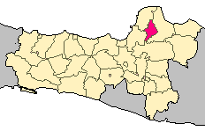
# North : Regency Jepara and Pati District
# East : Pati District
# South : District Grobogan and Pati
# West : Demak and the district of Jepara Regency
# North : Regency Jepara and Pati District
# East : Pati District
# South : District Grobogan and Pati
# West : Demak and the district of Jepara Regency
Distribution Area
The Holy District is divided into 9 districts, 9 villages, 123villages, 657 RW and 3453 RT. Based on zoning districts:
1. Excl. City: 18 villages, 9 villages
2. Excl. Bae: 10 villages
3. Excl. Jekulo: 12 villages
4. Excl. Dawe: 18 villages
5. Excl. Gebog: 11 villages
6. Excl. Jati: 14 villages
7. Excl. Mejobo: 11 villages
8. Excl. Undaan: 16 villages
9. Excl. Kaliwungu: 15 villages
Topographic Area
District City, Jati, Kaliwungu, Undaan, Mejobo,Jekulo Plain 28863.90 Ha
District Bae wide corrugated 6665.27 Ha
District Gebog and Dawe steep and wide 3047.00 Ha
District Dawe Very Steep wide 3939.50 Ha
District City, Jati, Kaliwungu, Undaan, Mejobo,Jekulo Plain 28863.90 Ha
District Bae wide corrugated 6665.27 Ha
District Gebog and Dawe steep and wide 3047.00 Ha
District Dawe Very Steep wide 3939.50 Ha
Most of the northern
region there is a mountain (Muria Mountain), with
the peak of Mount Sutorenggo (1602 meters), Mount Rahtawu (1522 meters), and
Mount Argojembangan (1410meters). Attack is
the largest river flowing time in the west,limiting
the District Kudus with District Demak